
Ocean Maps, a privately held Austrian surveying company, is a beneficiary of the 4D-REEF programme hosting one of the Early Stage Researchers, Roberto Giudici. They are contributing to the 4D-REEF programme with their cutting-edge interactive 3D underwater visualization software. Designed for leisure scuba diving planning, Ocean Maps unleashes the potential of immersive simulation for unprecedented dissemination accuracy.
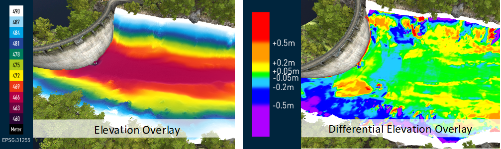
The image above shows an example of 3D visualisations of a hydroelectrical basin in Austria developed by Ocean Maps. Left panel: bathymetric map overlay on an absolute elevation scale. Right panel: differential bathymetric map overlay from two different surveys (2018 and 2019) computed on differences of 3D models (TIN).
A virtual dive in the Coral Triangle
Roberto’s challenge will be to visualize the outcomes of different ESR projects within the 4D-REEF programme. A large panel of results in ecology, biology and geological dating is expected to be embedded into a single, full modular tool.
Visualising scientific results in a meaningful and engaging way will be the key points for the success of this collaboration. This joint effort is meant to provide a unique virtual dive in the majesty of the vulnerable Coral Triangle. An experience targeting a large community of users, ranging from researchers to anyone willing to discover geological origins of coral reefs and potential impacts of climate change on these ecosystems.
Customization for 4D-REEF research outputs
Roberto will customize the Ocean Maps program to fit specific outputs generated by the other 4D-REEF ESRs. This phase requires a joint effort to ensure a pleasant interactive visualization of the evolution of reef dynamics through visual indicators overlayed on an immersive 3D scene. Software engineers at Ocean Maps will develop 3D libraries for visualization of environmental, biological and geological data and entities showing the effects of turbid influences on benthic community composition and estuarine driven lithification. Particular attention will be given to ease of use and computational efficiency to provide a smooth user experience. The program is developed in Unity, one of the most advanced 3D engines available. A set of basic functions will be created to give a first insight of the new functionalities and will be refined once the final datasets and results are available.
This cross-field experience will be a great enriching adventure, giving each researcher a new perspective of their project. Extensive coding will merge oceanic surveying and analysis for an exciting experience that will widen collaboration boundaries to a worldwide scale.
Written by ESR: Roberto Giudici
MSc in Computer Science, MSc in Geomorphological Science
Ocean Maps GmbH, Austria


